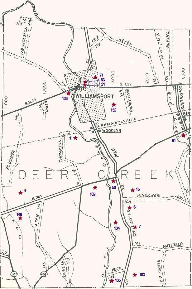
Cemetery locations were marked on this map according to maps in the County Recorder's Office which were drawn up by W.P.A. workers in the 1930's.
Those maps are not completely reliable as to exact distances, names of cemeteries, etc. However, this will be a reasonably reliable guide until we can get all the cemetery markers copied and locations pinpointed.
Bear in mind that several of these old cemeteries were moved to larger active cemeteries. Also, that in many instances individual families had a family member moved to their lot in another cemetery.
Some of the roads which were then (in the 1930s) township roads (T) have now been taken over by the county (C). However, only the prefix letter has been changed. The road number stayed the same. Township roads are shown on the map with dashes; County roads are shown with solid lines.
Most of the Pickaway County Cemeteries have been copied by Historical Society members and are on file at the Pickaway Co. Genealogy Library.
|
Map |
Cemetery |
Township |
Location Within Twp. |
| 1 | Alkire | Deercreek | 500 ft. South of R.R., on West bank of Deer Creek; approx. 1 m South of Williamsport; at North end of T-114 (Thompson Rd.) |
| 4 | Ater | Deercreek | .3 m North C-18; .7 m East S.R. 207 |
| 6 | Bennett | Deercreek | .2 m East C-23; .2 m South T-101 |
| 7 | Bennett Farm | Deercreek | 300 ft. East C-23; .8 m South T-108 |
| 15 | Brown | Deercreek | .3 m East C-23; .2 m North T-108 |
| 21 | Christian | Deercreek | .1 m North of U.S. 22; on C-23 (U.S. 22 & Water Street) |
| 39 | Frey Farm | Deercreek | 1320 ft. East S.R. 104; 1.9 m South S.R. 316 |
| 50 | Hanson | Deercreek | South side S.R. 138; .1 m West C-23 |
| 71 | Johnson | Deercreek | .5 m North U.S. 22; .5 m East C-23 |
| 83 | Methodist | Deercreek | East side C-23; .1 m North U.S. 22 |
| 91 | Mt. Pleasant | Deercreek | South side S.R. 138; .2 m West T-101 |
| 103 | Peck Farm | Deercreek | .1 m South T-109; .3 m East C-23 |
| 134 | Smith-Clark | Deercreek | 500 ft. West C-23; 1.1 m South S.R. 138 |
| 135 | Smith Farm | Deercreek | South side T-109; .3 m West C-23 |
| 136 | Springlawn | Deercreek | South side U.S. 22; .2 m West of Williamsport |
| 146 | Taylor Farm | Deercreek | 800 ft. South C-18; .5 m East S.R. 207 |
| 152 | Walston | Deercreek | .4 m South U.S. 22; .8 m East C-23 |
| 162 | Yates-Bazores | Deercreek | .7 m West C-23; 80 ft. South S.R. 138 |
Return to the Township Cemetery Map.
Top