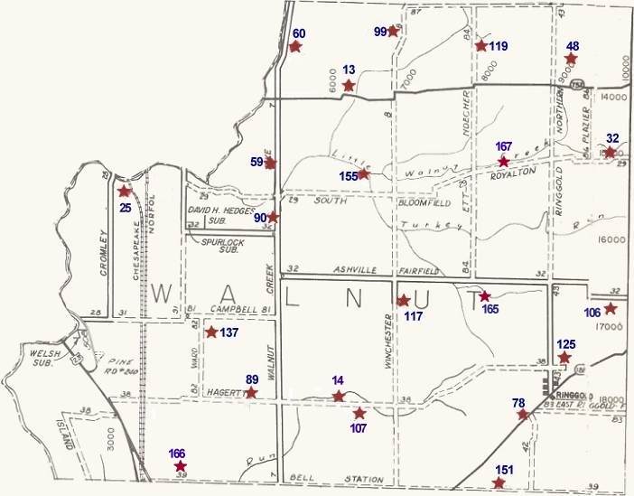
Cemetery locations were marked on this map according to maps in the County Recorder's Office which were drawn up by W.P.A. workers in the 1930's.
Those maps are not completely reliable as to exact distances, names of cemeteries, etc. However, this will be a reasonably reliable guide until we can get all the cemetery markers copied and locations pinpointed.
Bear in mind that several of these old cemeteries were moved to larger active cemeteries. Also, that in many instances individual families had a family member moved to their lot in another cemetery.
Some of the roads which were then (in the 1930s) township roads (T) have now been taken over by the county (C). However, only the prefix letter has been changed. The road number stayed the same. Township roads are shown on the map with dashes; County roads are shown with solid lines.
Most of the Pickaway County Cemeteries have been copied by Historical Society members and are on file at the Pickaway Co. Genealogy Library.
|
Map |
Cemetery |
Township |
Location Within Twp. |
|
167 |
Bethlehem Church Cemetery |
Walnut |
North of T-29; .2 mi. East T-84 - Removed to Reber Hill |
|
13 |
Brinker, B. Farm |
Walnut |
North of S.R. 752; .6 m West T-8 |
|
14 |
Brinker, C.F. Farm |
Walnut |
South side T-38; .5 m East C-7 - Some records refer to it as the Morris Cemetery. Removed to Reber Hill. |
|
25 |
Cromley, Wm. Farm |
Walnut |
.5 m West of intersection of T-31 & T-29 - Records show many bodies removed to Reber Hill, but unknown whether all were moved. |
|
32 |
East Union |
Walnut |
North side T-29; .2 m West S.R. 674 |
|
48 |
Hall Farm |
Walnut |
.3 m North S.R. 752; .2 m East T-43 - Moved to Reber Hill. |
|
59 |
Hoover |
Walnut |
West side C-7; .4 m North T-29 |
|
60 |
Hoover (Ira) |
Walnut |
300 ft. East C-7; .7 m North S.R. 752 |
|
78 |
Lutheran Church |
Walnut |
North side S.R. 188; .5 m West C-43 |
|
166 |
McDonald Cemetery |
Walnut |
North side T-39; .7 mi. East of C-511 - Bodies removed to Reber Hill |
|
89 |
Morrison Farm |
Walnut |
North side T-38; .4 m West C-7 - Land Owner petitioned before 1900 to have the bodies moved to Reber Hill. Records exist at Reber Hill. |
|
90 |
Mt. Herman |
Walnut |
West side C-7; .1 m North C-32 |
|
99 |
North Union |
Walnut |
.3 m South T-87; 500 ft. West T-8 - Moved in 1933 to Reber Hill. No known record of burials. |
|
106 |
Peters Farm (Chester) / Tallman (Also called Old Ringgold years ago) |
Walnut |
.1 m South C-32; .1 m West S.R. 674 - Some families were moved to Reber Hill. |
|
107 |
Peters Farm (Flora) |
Walnut |
North side T-38; .5 m East C-7 |
|
117 |
Reber Hill |
Walnut |
East side T-8; .5 m South C-32 - Bodies from 13 small cemeteries have been moved into Reber Hill. In some cases records give name and name of the cemetery they were removed from. |
|
119 |
Reed Wm. Farm |
Walnut |
East side T-84; .3 m South T-87 - Records at Reber Hill state "14 unknown bodies from Reed Cemetery." |
|
125 |
Ritter |
Walnut |
.1 m North T-38; .3 m East C-43 |
|
165 |
Seitz Farm / Brown Family |
Walnut |
.2 m South C-32; .1 m East of farm lane - Some Brown burials were moved to Reber Hill. |
|
137 |
Stage |
Walnut |
.1 m East T-82; .2 m South T-81 - Moved to Reber Hill. |
|
151 |
Wagner Farm |
Walnut |
.5 m East S.R. 188; North side T-39 - Some bodies removed to Reber Hill. |
|
155 |
Weaver Farm |
Walnut |
.3 m North T-29; .4 m West T-8 - Moved to Reber Hill. First burial in the township was made in this cemetery. |
Return to the Townships Cemetery Map.
Top